Chalton
About
An east facing hill overlooking a railway line with restricted top and bottom landing areas that make this more suited to Paragliders. The site is a short walk with limited roadside parking. There is no farmer imposed restrictions on numbers but is only available from February through September. Should provide cross country potential and being our most easterly Paragliding site enjoys therefore the greatest distance before airspace restrictions are encountered. There is no bowl like Whitewool and Mercury so takes less north.
Possible air ambulance landing location ///drag.tweed.exhaled
Communication radio frequency 143.925
Access
From the A3 turn off at the signpost to Chalton. In the village take the left fork before the pub. This takes you down to the bottom of the hill. Follow it along till you are almost at the footpath. Park off the road in any of the small parking areas clear of traffic. Walk to the footpath that leads UNDER the train tracks and back up the hill.
Parking
Any small parking space on the bottom line.
OS Map
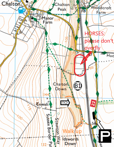
Site OS Map Click to open
Details
Location LAT/LNG | 50.9299 / -0.9540 |
Grid Reference | SU 734 151 Sheet 197 |
What 3 Words | seat creatures drop |
HG Pilot Requirements | CP+10 unless by prior agreement with a coach |
PG Pilot Requirements | CP+10 unless by prior agreement with a coach |
Wind Direction | 020 to 100 degreesWINDdirection |
Height | 144m (472ft) |
Top To Bottom | 82m (269ft) |
Nearest Phone | Chalton Village |
Site Contact | Andrew and Trish Fisk, Heberdens Farm |
CP: Local Flights Only
The BHPA has clarified that Club Pilots (CP) must only make 'local' flights to remain insured by the BHPA 3rd party insurance. A local flight is one where the pilot remains within an easy glide of the official landing field. This will differ based on the conditions of the day. Club Pilots should take care to remain within an easy glide of the official landing field at each site.
Map
Site Rules
- A briefing is advisable from a pilot that has flown Chalton
- If the bottom landing is closed then this site is not suitable for hang-gliders. Paragliders must have minimum C.P. plus 10 hours.
- The site is closed from October through to January inclusive.
- There is no site fee, however, please text RJ Macaulay (the site supervisor) with the numbers of people flown every time. I need this information for the farmer.
- Please do not overfly the horses to the north of the hill.
Hazards
Railway line immediately in front and forming the lower slope boundary.
Power lines to the south cutting across the hill.
This is a tricky hill with a lot of scrub to put your wing in. It is probably not suitable for light wind days.
The north end of the ridge seems to be quite rough at times.
Takeoff
Any area free of scrub. The best area is on the south end of the slope.
Landing
Bottom landing field is available when not in crop. If in doubt ask at the farm.
Consider
Pilots with less than C.P. plus 10 hours will find Whitewool or Mercury more suitable.
Cross Counry
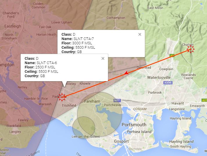
Chalton is further from airspace and is always uncrowded – you can more or less have the hill to yourself!
Leaving the Hill
Thermals come up all over the slope though being fairly low you require a pretty committed climb to get away. Thermals frequently seem to leave the hill to the North and South ends of the slope.
First XCs
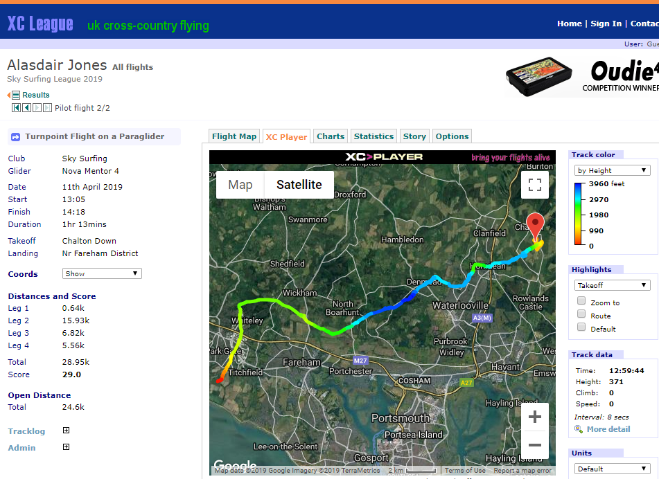
Once you climb out you can head downwind over Clanfield and down into the corner of airspace. The flight shown here is 25km.
For the more adventurous
As with Whitewool and Mercury it is tempting to think that it may be possible to clear Southampton airspace to the north if the wind heads south while flying.