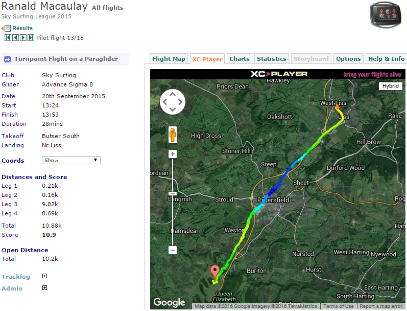
Butser South
About
An excellent training and/or testing slope but a very gentle incline. Can suffer rotor in winds off to the west. A useful alternative slope when the sea-breeze wind shift renders the West site slope unflyable. Slope is subject to scrub regeneration management and will therefore become less useful. Takeoff is right next to the corner of the trees. Soaring this slope is difficult but not impossible.
NOTE: Pilots must be members of the Sky Surfing Club or one of the clubs the SSC has a Reciprocal Agreement with. Visitors and guests are not permitted.
Possible air ambulance landing location ///bibs.robot.fish
Communication radio frequency 143.925
Access
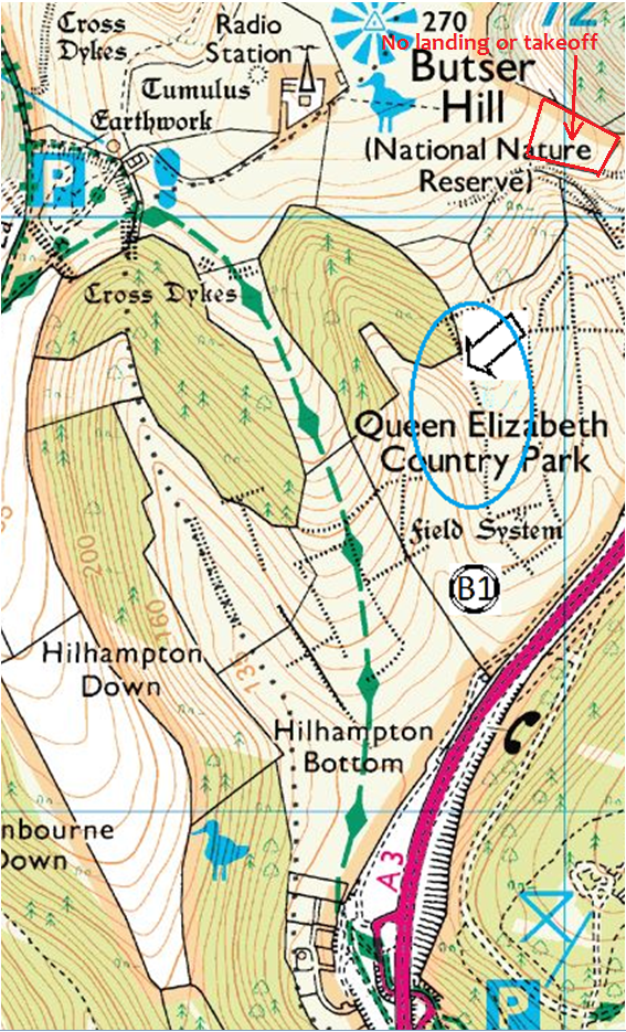
From the duty car park carry across the top of Butser, through the gate east of the radio mast and towards the A3 and over the stile in the top fence. Then follow the tree line down to the rigging area.
Alternatively, park at the main QECP car park, and head out of the country park and under the A3 underpass. Turn left into the parkland at the bottom of butser hill, and follow the track round to the right and up the furthest spur to the launch area.
Parking
Either park at the duty car park at the top of Butser Hill, or in the QECP main car park
OS Map
Site OS Map Click to open
Details
Location LAT/LNG | 50.972945 / -0.978256 |
What 3 Words | stated swanky lilac |
HG Pilot Requirements | CP |
PG Pilot Requirements | CP |
Wind Direction | 200 to 255 degreesWINDdirection |
Height | 180m (591ft) |
Top To Bottom | 35m (115ft) |
CP: Local Flights Only
The BHPA has clarified that Club Pilots (CP) must only make 'local' flights to remain insured by the BHPA 3rd party insurance. A local flight is one where the pilot remains within an easy glide of the official landing field. This will differ based on the conditions of the day. Club Pilots should take care to remain within an easy glide of the official landing field at each site.
Map
Site Rules
The whole slope and landing areas are within the Park and so there is no need to seek prior permission. One glider in the air at a time and hang-gliders must wait until the bottom landing area is clear. The only exception is the small fenced field at the back of the rear (northerly) bowl.
Hazards
Modern hang-gliders in fair conditions could glide beyond the normal bottom landing.
Rigging
Back up slope from the Launch area.
Takeoff
Immediately below the wooded area.
Landing
Down slope into the bowl or side landing onto the slope.
Consider
This is an extremely limited site, probably only one at a time. Share the time and space. Aeromodellers use the slope above the wooded area and generally stay back, however the glider launch site is below their line of site and unintended conflict for air space can occur. Make contact so that they know you will be flying from lower down, keep a close watch for models and do not assume that you have been seen at launch.
Cross Counry
Only for the most determined pilots.
Leaving the Hill
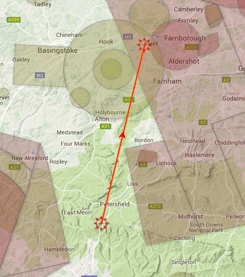
The thermals seem to develop quite well in the valley and they have to be hooked and followed quite aggressively. You have to leave the hill very low staying with the thermal. Once over the back the ground drops away and you have more searching time towards Petersfield.
First XCs
Not suitable.
For the more adventurous
If we can get away from here in a southerly then it may be possible to clear airspace but it will be a real challenge. The wind will be trying to take you towards Farnham and Farnborough.