Mercury
This site is closed until further notice.
About
Also known as Wether Down.
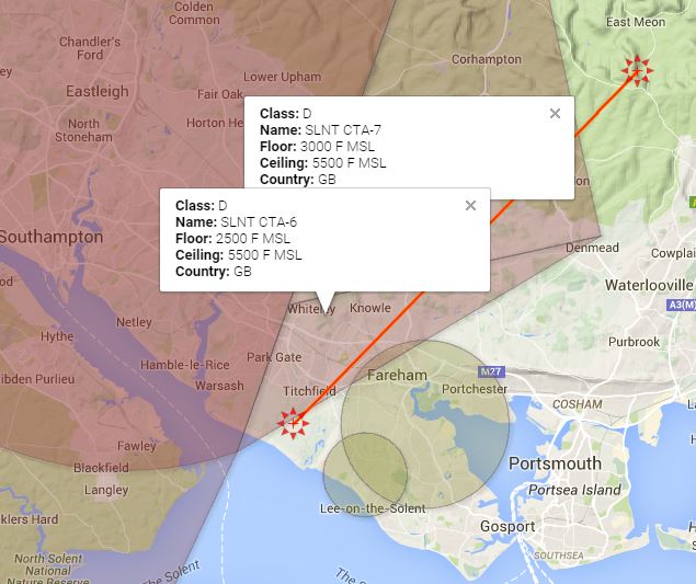
An east facing ridge of approximately 1.25 kilometres with a bowl at the south end, shallowing to the north but soarable for its full length. An excellent thermal site but potential dulled by the proximity of restricted air space (Soton CTA) only 2 miles downwind. Farm buildings to the north generate the house thermals. Good thermal days can be overcome by sea-breeze in mid-afternoon.
Access
From A3(M), turn off west to Clanfield. At 1 mile, turn right past Rising Sun Pub. Follow signs to East Meon, approx. 3 miles, turn left at signpost to Warnford. Immediately past the Ecology Centre, turn right into a farm track, follow for 500 metres to the gate (past twin radio masts).
Parking
Through last gate (beyond masts), in top field to left (north) of the gate and up against the fence. On occasions and only at the convenience of the Farmer, parking may be changed to the yard area immediately adjacent to the barns alongside the radio masts and accessed through that gate.
OS Map
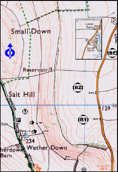
Site OS Map Click to open
Details
Location LAT/LNG | 50.974114 / -1.038353 |
Grid Reference | SU 675 197 SHEET: 185 |
What 3 Words | truck rooting whirlwind |
Wind Direction | 045 to 100 degreesWINDdirection |
Height | 225m (738ft) |
Top To Bottom | 91.4m (300ft) |
Nearest Phone | East Meon village |
Site Contact | Mr George Atkinson, Lower Farm, East Meon |
Map
Site Rules
- This is a strictly members only site, plus reciprocals.
- “Daily, and by personal appearance (rather than a phone call), the first person on site must gain permission from Lower Farm to fly and determine whether a bottom landing field is available.”
- This is CP + 10 hours for PG due to the complexities of flying with modellers on one side and HG on the other.
- A site fee of £1 per pilot is to be deposited into the collection box by the entry gate.
- Site reverts to soaring only (CP+10hours) when no bottom landing available.
Hazards
There have been some close encounters with the power lines in the top field. The slope will take only a little southerly wind component. Can be turbulent in strong winds partly due to the tree line immediately below the ridge and a funnel effect in the bowl.
Paragliders must abide by the no inflating or kiting anywhere in front of take-off.
Space has to be left between the PG Take-off and the aeromodellers in case a HG overshoots while top landing. They have to have an escape route clear so all pilots have to return and ‘cluster’ at the take-off areas. It is because of these constraints that Mercury is CP + 10 (i.e. NO RED RIBBONS)
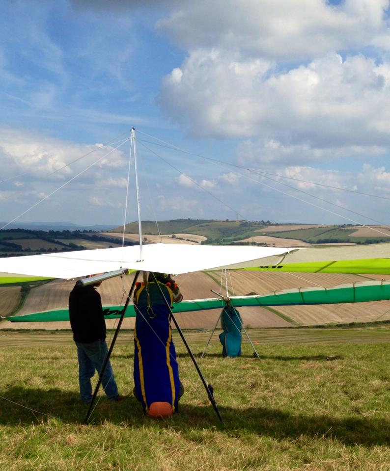
Takeoff
From the shoulder of slope over the fence. Hang-Gliders from alongside the southern fence, Paragliders a minimum 200 metres from the southern fence, to give separation from the Hang Gliders launch area.
Landing
When available, the main bottom landing fields are B1 and B2 immediately below take-off do not assume these to be available but check first. In B1 a lump just before the road can create difficulty during the final glide for the unwary Hang-Glider pilot, leaving him stalled over the road. In an emergency when bottom landing fields B1 and B2 are not available, BE can be used by Hang-Gliders but, is probably too far for Paragliders who will be then restricted to slope landing at the front of the take-off hill in which case, beware of rotor from the tree line. Top landing; is straight forward and clean for paragliders, Hang-Gliders should normally set up approach from the south to avoid the aeromodellers circuit at the north end of the ridge.
Consider
The bottom landing fields are subject to arable farming and may only be used when cut or ploughed and with the farmers express permission. Whitewool and Chalton offer good alternative sites for Paragliders. The site is usually closed during the shooting season, October to February. Consideration to the Modellers. The following agreement exists between the Meon Valley Soaring Association and the Sky Surfing Club to minimise points of conflict between the users of the hill, and to minimise the risks of mid-air collision with models when we are flying.
A corridor of priority airspace for models is designated by;
- Two white markers mounted on top of fence posts (this is only clearly visible from the air). This position is between our Southerly end of the ridge and the modellers launch point.
- The Northern boundary of this airspace is marked by the fence line beyond the modellers which is the Northern boundary of the field. Hang/paragliders, must not fly in this region.
Exceptions to this rule are :-
- Hang/paragliders can transit the region to fly the ridge to the North, but this must be done in a clean, clear pass and at a height of not less than 150ft. ATO.
- Hang gliders can return below this height to avoid bottom landing in difficult circumstances. The condition being that the pilot must exercise the utmost caution and airmanship, in order to avoid collision between him/herself and models, or cause mid-airs between models.
- Climbing out in a thermal will not need to be terminated across this region if, the climb rate is good and the drift rate ensures a quick transit and clearance of the region. Thermalling in light airs, with slow drift is not acceptable in the region. The position of the markers is provisional and they may be repositioned if necessary, dependant on mutual agreement.
Please abide by the rules and do not fly in front of the modellers.
If you see other pilots doing so, please remind them not to do so.
It is the responsibility of everyone to ensure we all do the right thing to maintain good relations with the other hill users and landowners.
Cross Counry
Mercury is a surprisingly difficult site to go XC from for a paraglider and with its hang gliding friendly top landing there is a lot of mixed traffic. It is essential to have a GPS and proximity alarm when flying here due to the airspace downwind.
Leaving the Hill
Thermals come up all over the hill, often quite far out front though so expect to need to push forwards. Be aware of the RC modellers and try to give plenty of space for mixed traffic.
First XCs
Mercury is limited by airspace, but is suitable for first XCs. Once you are away from the hill, head south down towards the corner of airspace or head back keeping under the airspace. Sadly it is quite low and there is a spur that you have to cross that is even lower.
For the more adventurous
Mercury is very limited due to downwind airspace.