Harting Down
About
NOTE: Harting is strictly Members-Only, (no Reciprocals).
Part of the South Downs and owned by the National Trust (NT), the Club has a formal Licence to fly this site.
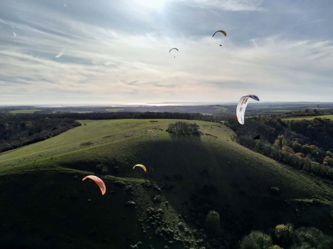
A steep northerly ridge including three main bowls. A reasonable thermal site, though often effected by sea-breezes on light wind days. Will take a lot of east and beyond Beacon Hill becomes more NNE. A ridge run of 8km, to Cocking and beyond is possible.
Access
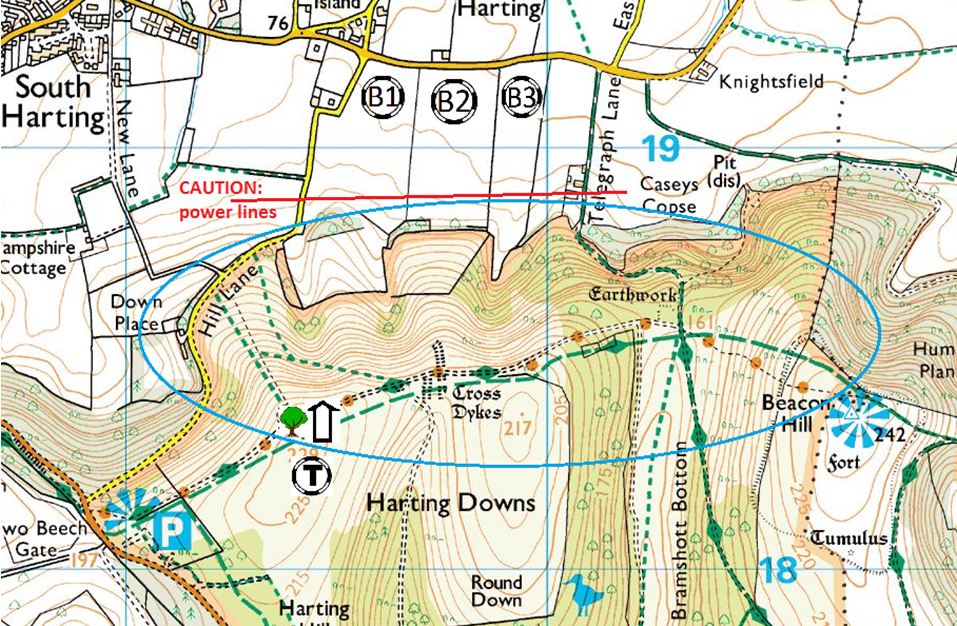
Travelling north on A3(M), turn off at first sign post to Petersfield. Approaching Petersfield town centre, take the B2146 east to South Harting. In South Harting at T-junction, turn right (south) and continue for 1/2 mile. Fork left onto B2141 and continue uphill for 1/2 mile. Just past Hill Lane, turn left into car park, (NT HARTING DOWN).
Parking
Use the open tarmac area. During summer months the grass picnic area may also be open and you can drive across to the boundary fence to park. A daily parking fee is payable through the ‘Ringo’ system.
Details
Location LAT/LNG | 50.959358 / -0.870260 |
Grid Reference | SU 805 184 Sheet 197 |
What 3 Words | heartened indeed remotes |
HG Pilot Requirements | CP+10 unless by prior agreement with a coach |
PG Pilot Requirements | CP+10 unless by prior agreement with a coach |
Wind Direction | 340 to 040 degreesWINDdirection |
Height | 229m (751ft) |
Top To Bottom | 140m (459ft) |
Nearest Phone | South Harting |
Site Contact | National Trust Warden – Marden Farm – |
OS Map
Site OS Map Click to open
OS Map
Site OS Map Click to open
Map
Site Rules
- First person on site checks bottom landing field availability with Marden Farm.
- If sheep are grazing on the ridge top or face, permission to fly must first be obtained from Marden Farm. Avoid landing or overflying fields with sheep in.
- Do not obstruct, launch or land across footpaths.
- Capacity: 6 in reasonable ridge lift, perhaps more in good thermals.
- The site reverts to soaring only when no bottom landing is available.
- NT rules dictate a maximum of 6 rigged and active gliders on the ground, outside the rigging area. Please ensure all equipment is kept between the paths other than immediately before launch or immediately after top landing.
- Strictly member’s only – no visitors or Reciprocals. BHPA and SSC membership cards must be carried at all times and produced on request by NT staff.
This site is astride the South Downs Way and is owned by the National Trust. It is area of major environmental significance within the South Downs National Park.
It is heavily used by walkers, bikers, horse riders and aeromodellers. Conflict with other users will come to the attention of the Warden and can jeopardise our use.
The top (south) path is a bridleway in regular use, but it is not visible from the launch area. Some caution is needed before take off to avoid alarming horses. All pilots should monitor for riders approaching and warn those in the launch area accordingly.
BE EXCEPTIONALLY CONSIDERATE and give your time to the encouragement of public interest in our sport.
Hazards
Launch can be rough in strong winds and the gentle reverse slope behind top landing can cause turbulence low down. Power lines cross most bottom landing fields. It is best to leave at ridge height for all but the nearest bottom fields.
Rigging
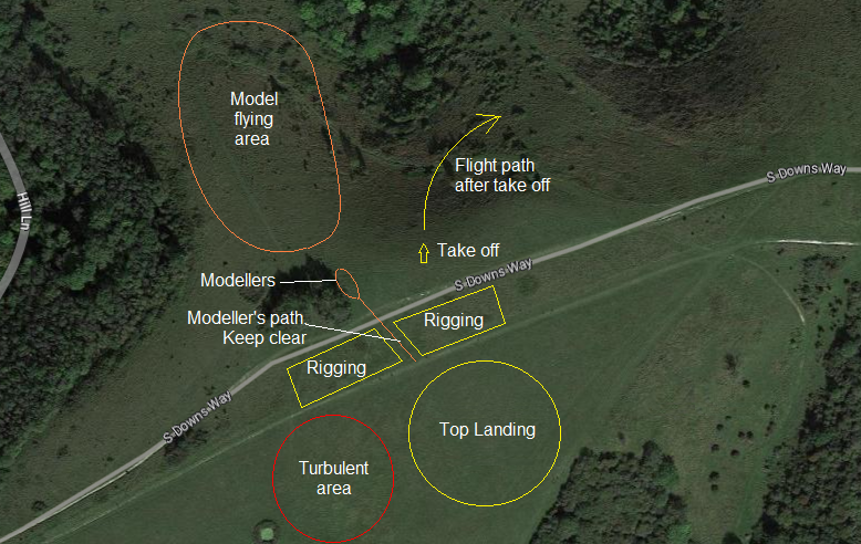
Unload and carry equipment across the picnic area, through the gates to the east. Follow the footpath to the rigging area between the two footpaths, behind the clump of trees and east beyond the hollow. Rig only in this area (behind take-off). ALL equipment MUST be parked in the area between the paths unless launching or landing. The take-off area should be kept clear at all times.
Takeoff
From the shoulder of the hill, in front of the rigging area, north of both footpaths. Launch from the middle of the first bowl, away from the trees and the modellers. Make your first turn to the right, (east) along the ridge.
Launches should proceed one at a time for both hang gliders and paragliders, using the same take-off area.
Landing
Bottom landing fields are immediately below and to the right, (east) of take-off. All are privately owned and subject to continuous rotation of crops. The duty field for the day must be checked with the farmer. Be aware of the profusion of power lines.
Top landing is on the top of the ridge immediately behind take-off, but avoiding the footpaths and clear of the clump of bushes which generate some rotor. Paragliders may also land on the spur to the right, (east) of launch but all equipment must be carried back to the rigging area between the paths.
Slope landing is not advised. The proximity of the trees below and the attendant turbulence make slope landings a hazardous manoeuvre. The slopes have numerous footpaths used by walkers.
Models
The site is shared with the MVSA. The modellers fly over the spur to the left of take off and stand close to the bushes. They require a path back (south) from their assembly area to the top of the hill so they can walk back to top land their models. Please keep a clear path through our rigging area.
To avoid conflict:
- Launch from the middle of the bowl
- Turn east after take off on your first beat
- Avoid flying in front of the modellers over the left hand (westerly) spur
In the event of any issues please talk to the modellers at the time. They are close so it is easy to liaise.
Cross Counry
Harting is probably the best bet for a decent first XC from a SSC site. The thermals come up all over the hill and there is very little airspace to worry about.
Leaving the Hill
Thermals come up all over the place at Harting and you can get really high above the hill here. You will often see people get to one of the many spurs and there they are able to push forward into a thermal.
First XCs
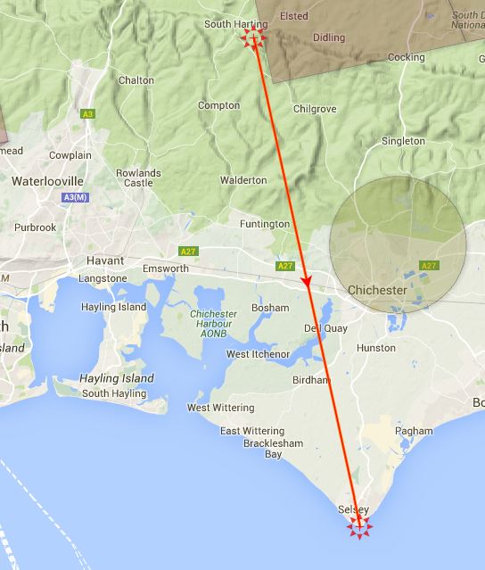
Harting is a super location for making that first break from the hill. You will only need one additional climb on a typical day to reach Bosham and the South Coast! Heading due south you will see a number of smaller hills that face into wind. If you can overfly these, they seem to work well as thermic triggers. Once you get to the A27 look for seagulls and there are good climbs to be had that will take you to Selsey.
Places to aim for. Selsey is almost 30km and is a classic flight. This flight is shown on the air-map above.
For the more adventurous
Harting is a perfect site to connect with the sea breeze. Keep an eye on the curtain of clouds as they develop and move inland and make sure you get away before the Sea Breeze Front reaches the hill! Once you are in the Convergence you can fly down the coast to Brighton and beyond! It should also be possible to do a thermic ridge run down (and back?), to Devil’s Dyke. There are some big gaps to jump so you need a decent thermal day to make it work.